|
|

|
|
|
|
The Regina City Geoenvironment
|
Regina is situated on the Assiniboine River Plain approximately 30 km south of beautiful Qu'Appelle Valley, a huge glacial
meltwater channel whose 1 to 2 km wide floodplain lies some 100 m below the adjoining upland. |

Fig 1: Assiniboine River plain and surrounding uplands. |
To the southwest of the Assiniboine River Plain lies the Missouri Coteau Upland, a hummocky ice-
disintegration terrain. To the east, seemingly stretching away forever, is the rolling Moose Mountain Upland (Fig. 1).
Our city of about 187, 600 population is located on the bed of glacial Lake Regina, a 6000 km2 extinct ice-marginal lake whose waters reached 50 m in depth about
14,000 years ago (Fig. 2). |

Fig 2: Glacial Lake regina approximately 14,000 years ago. |
Up to 12 m of sticky montmorillonitic clay was deposited on the bottom of Lake Regina (Fig. 3).
Up to 200 m of complexly interlayered till and stratified sediment
(Fig. 4) overlies Upper Cretaceous Bearpaw Formation |
bentonitic marine shale. Testhole drilling in the city suggests this formation is cut by vertical faults associated
with collapse following dissolution of underlying Prairie Evaporite strata (Fig. 5). |
For over 70 years, beginning in the 1880s, Regina residents relied on groundwater for their water supply, obtaining water from
well fields tapping intertill sand aquifers (Fig. 8). These same
groundwater sources are now supplemented by surface water diverted down the Qu'Appelle Valley from Lake Diefenbaker. At present,
aquifers north and east of the city are said to supply roughly 10 million m3 of well water annually to the city. The Zehner and Northern
aquifer systems, as well as most of the Regina aquifer system, are protected from contamination by layers of relatively low permeability
Regina clay and clay-rich till. However, the aquifer |

Fig 6: Log of testhole at the intersection of Williams Street and Campbell Street, Regina. |
underlying the Condie Moraine, which trends WNW-ESE a short distance north of the city (
Fig. 9), is vulnerable to contamination because it is located nearer ground surface and includes a highly permeable stratum
(Fig. 10 underlying Regina's industrial and waste-disposal areas. |

Fig 7: Stratigraphic section along Albert Street |

Fig 8: Main drift aquifers in the Regina area. |

Fig 10: Log of testhole at the intersection of Williams Street and Campbell Street, Regina. |
Regina clay. The Regina Plain has a history of flooding (Fig. 11);
the evidence of thismay be seen in the high dikes constructed in the area west of Wascana Lake |
| on Albert Street. For many decades this low-lying area was periodically flooded. Another problem involves popouts in concrete
sidewalks and driveways, caused by particles of high moisture absorbing opaline shale in fine aggregate, obtained from complexly bedded subglacial
and ice-contact sand deposits located a few kilometres east of the city, near Pilot Butte (Fig. 12).
Unquestionably, however, the most extraordinary geohazard Regina residents have experienced occurred at 10:20 p.m. Mountain Time on Saturday,
March 15, 1909. Just then a 5.5 magnitude quake shook the city (Fig. 13), toppling
dishes from shelves and sending electrified residents into the streets.
|

Fig 11: Satellite image of Regina Plain following widespread flooding, April 1974. |

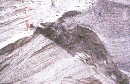
Fig 12a: Block of sand enclosed in till. |

Fig 12b: Block of till enclosed in sand. |
Q. Fig. 12a - Why is the block of light-colored stratified sand more or less intact and little-deformed in what looks like till? Fig. 12b -
How did the block of till get deposited in clean, well-stratified sand? In the early '50s a novel test, called the Inner Lip Test, was designed
to confirm the identity of popout-prone, moisture-imbibing opaline shale in concrete aggregate mixes. Can you describe and demonstrate
how this test works? What makes this siliceous shale so deleterious in concrete? |
|
|