|
|

|
|
|
|
Stop 5 - Photolineament Pattern on the Souris Spillway
The meltwater-eroded Souris Spillway surface southwest of Estevan and south of lower Rafferty Reservoir is lined with several sets of fine lineaments, termed 'microlineaments', which are visible on airphotos. They have been identified and mapped from remotely sensed imagery, and their trends and patterns correlated with subsurface geological and geophysical datasets (see Fig. 31 insert). A regionally pervasive NE-SW set of surficial lineaments roughly parallels a dominant NE-SW bedrock joint fracture set, which in turn is closely aligned with the mid-continental plate tectonic movement trajectory and maximum horizontal compressive stress in the earth's crust, SHmax (see Fig. 31 insert). In this region of southeastern Saskatchewan, that trajectory orientation roughly parallels the azimuth (about 230°) of the earth's past and current crustal movement rate of about 2.5 to 4.0cm/year--which is approximately the normal growth rate of our fingernails. Significantly, such a phenomenon is a factor in determining the direction of horizontal oil wells to obtain higher production yields.
Because their enigmatic origin has been debated for more than 40 years, we pose the following questions (refer to see Fig. 31 insert): Are the intersecting sets of surficial microlineaments caused by: |

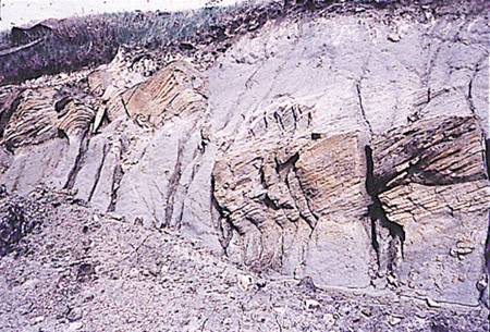
Fig 32a: Faulted sandstone bed in an abandoned railway cut near Rafferty Dam. |
|
Glacier flow that oriented the clasts (boulders and cobbles) in subglacial till, forming a glacially fluted lineament pattern that was
exhumed and exposed during catastrophic meltwater erosion? |
|
Leaching along systematic fractures in hard till and bedrock, and removal of soluble and non-soluble material along fractures,
resulting in small settlements along the lineaments? (Concentration of higher moisture and organic contents along subtle linear
depressions gives rise to their expression in airphotos, a pattern that is virtually impossible to detect on the ground.) |
|
Propagation of fracture lineaments from depth, possibly associated with small cyclic stresses or with earth movements caused by:
unloading related to deep post-Cretaceous erosion, salt dissolution in underlying evaporite beds, glacial rebound,or someother mechanism? |
Q Figs. 31, 32a, 32b, 33a, 33b - What is the origin of faulted beds in the area around Tableland, Sk.?
Q. Figs 29, 30 - Why do the small plateau-like, erosional-remnant "islands", only a metre or so high, have teardrop shapes pointing downstream?
And why do parrallel linear microdepressions originate from the downstream side of small plateaus?
Q. - What interferences might be drawn from the dense concentration of boulders ('boulder lag') on the Souris Spillway floor, if you were bidding
on a contract to construct an underground water-supply pipeline from the hamlet of Hitchcock to the Souris River?
Q. Fig 31 - Looking at the array of inset diagrams in Fig. 31, can you provide a reasonable
explanation for why different orientations of different surficial microlineaments sets tend to match the orientations (strikes) or deep-
seated bedrock structures located deep in the earth's crust? In fact, how can you account for two or more lineament sets having
different orientations on the melted-eroded Souris Spillway floor? And what is the genetic connection between the orientation of slight,
subtle surficial lineaments on the upland adjoining the Souris River valley and long, linear segments of steep river valley walls west of
Rafferty Dam?
Q. fig 31 - Is there any geotechnical explanation for a possible genetic connection between matching locations of the roughly
concentric oval microrelief rings at ground surface (see inset) and a 60-m-high, oil-bearing carbonate
reef located some 2600-m below ground surface? Is a possible explanation and analogue the very significant surface settlements
occuring at some potash mines, resulting from mining a few metres of potash 1000-m below surface? |
|
|